


Introduction
Valrie Grant is the most charismatic and professional podcaster of the geospatial industry:
She is also deputy chair of the board of the UNGGIM - PSN. Don’t worry, I unpack that shortly. Two guests ago we had someone else from the same UN body, Nadine Alemeh:
Whilst researching Nadine’s career, I came across minutes of a meeting of the UNGGIM-PSN. They mentioned Valrie as attending. I knew her name from listening to her podcast on the way to work in London. Nadine is also a board member of the same body. Valrie is a step higher, deputy chair of the board. Curious, I reached out to Valrie and she was gracious enough to come on the show an explain to us the private sector network of the UN’s committee of experts on global geospatial information management (UNGGIM - PSN):
The UN
Since this episode is about the United Nations, let’s step through the hierarchy to understand the part of it that we focus on:
The United Nations (UN) was founded in the aftermath of World War 2 on October 24, 1945. It is an international organization promoting peace, security, human rights and sustainable development through cooperation among its 193 member states.

Its Economic and Social Council (ECOSOC) was founded the same year. This is one of six principal organs of the United Nations, established under the UN Charter to promote international economic and social cooperation and development.
Serving this council is the Statistical Commission. It was founded 2 years later in 1947. This is the primary global body for setting international statistical standards, coordinating statistical activities, and supporting the development of national statistical systems to promote reliable and comparable data worldwide.

The UN-GGIM (United Nations Committee of Experts on Global Geospatial Information Management) serves this commission. It was founded in 2011. It is a global initiative to promote and coordinate the use of geospatial information for sustainable development and decision-making. It has produced several frameworks. An example is the United Nations Integrated Geospatial Information Framework (UN-IGIF) mentioned by Valrie on the show. Another one worth mentioning is the third edition now of their Future Trends in Geospatial Information Management report.


Finally, the Private Sector Network of the UNGGIM was founded in 2016. It is a platform that brings together private sector entities to collaborate with governments and international organizations. It promotes the use of geospatial information for sustainable development and global challenges. These are the member organisations.

That is a lot to take in! You will see that I certainly struggled with all the acronyms in the episode. It was nice of Valrie to be so patient about it. There was a strong message from Valrie throughout encouraging organisations to join the Private Sector Network. So, here is the form to nominate your organisation.
How to Run a Company
It’s interesting to see the founding members from 2016:

Some of them are the most well known companies and organisations in geospatial. The one at the bottom left, is Valrie’s - GeoTechVision. I love seeing this small company from Jamaica mentioned amongst heavy hitters like Oracle.
Speaking of which, we are presented in this episode, and the one with Frank Romo, with an ideal vision of company. As Frank showed:
…a great way to deliver on a company’s diversity, equality, inclusion and action goals is to be a community organisor. This makes the justice and social uplift work of a company far more intentional and deliberate. Then if we also follow Valrie’s example and enroll the company in the UNGGIM-PSN, then this means the company also contributes at a global level.
I like that the podcast has gotten to this point. It has taken some effort and persistence, but there have been some really great messages from recent guests. Given that most episodes follow a standard template for reviewing geospatial businesses, usually we have the chance to learn from a geospatial entrepreneur. As such, the podcast is working well as a mechanism of advice not only for the business of geospatial, but proper community membership and benefit.
The Line/Neom
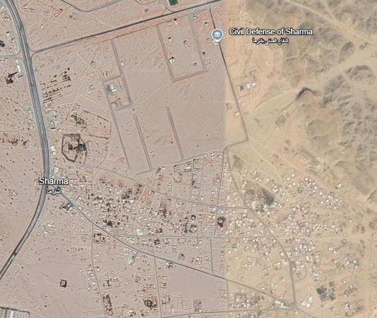
Finally, I was happy to continue the Saudi thread. Given that I was talking with someone involved in the UN, I had to present the issue of tribal landowners vicitimised by Neom and The Line. The aftermath of one community being cleared is shown here:
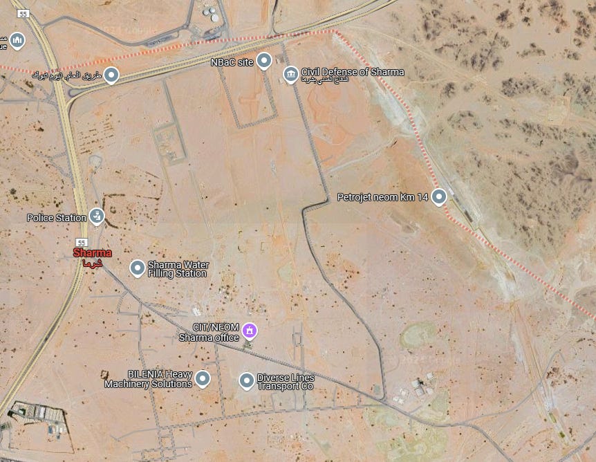
In Google Earth it is shown as having plenty of buildings until October 5th, 2020:
The next image is September 14th, 2021 and most buildings have been cleared:
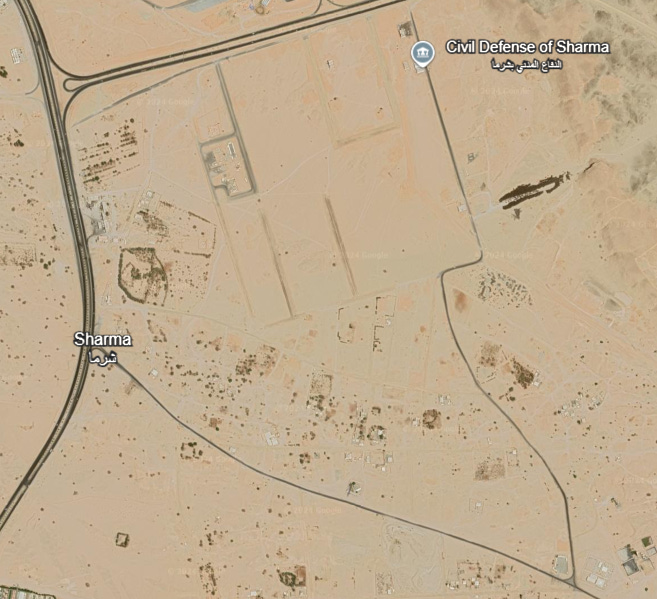
You can have a look more yourself using Google Earth. It is not a happy circumstance according to ALQST’s latest briefing paper. We will see how far I can take this as a demonstrator case for the power of geospatial to shine a light on injustice. A starting point would be to train a Support Vector Machine classifier to detect buildings, or at least built up areas, across Tabuk Province in 2020, then 2021 imagery. Tutorial here. We can also just go straight to Overture Maps Foundation’s building footprints dataset and look at change over time in that. Here we can see that they have been super helpful and provide a webmap to browse it right away:

What we know immediately is that these building footprints are at least 3 years out of date, as new satellite imagery, shown above, reveals that all these buildings are now gone. Something to reach out to Overture Maps Foundation about.
THE GEOSPATIAL INDEX
The Geospatial Index is a comprehensive listing of all publicly traded geospatial businesses worldwide. Why? The industry is growing at ~5% annually (after inflation and after adjusting for base rates). This rate varies significantly, however, by sub index. For $480,000 to start, this growth rate is $5,000,000 over a working life. This channel, Bluesky account, newsletter, watchlist and podcast express the view that you are serious about geospatial if you take the view of an investor, venture capitalist or entrepreneur. You are expected to do your own research. This is not a replacement for that. This is not investment advice. Consider it entertainment.
NOT THE OPINION OF MY EMPLOYER
NOT YOUR FIDUCIARY
NOT INVESTMENT ADVICE
Bluesky: https://bsky.app/profile/geospatial.money
LinkedIn: https://uk.linkedin.com/in/geospatialindex
Watchlist: https://www.tradingview.com/watchlists/123254792/
Newsletter:

Podcast:

Share this post