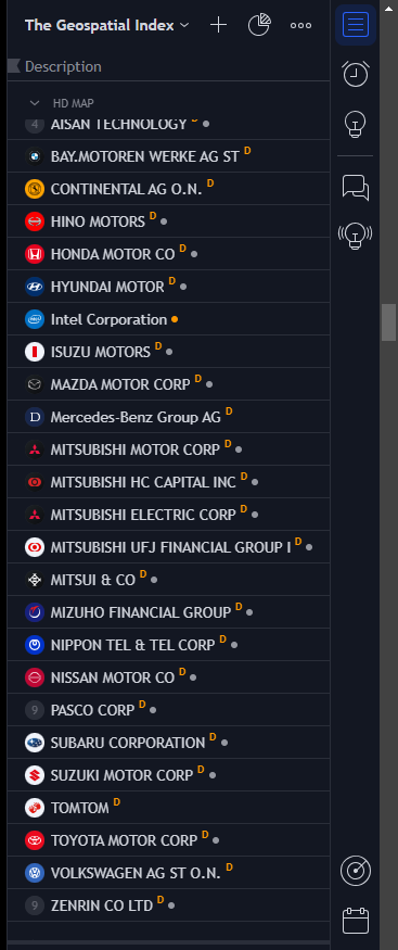
This is the second episode with Stephanie May. She talks about how the first world basemap was created for Facebook. We also spent some time covering how dark mode is produced for a map. Some discussion occurred about human factors and human/computer interface observations about the navigation display system offered by Tesla. This lead us to HD mapping and the pattern of coalitions forming between corporations that rely on this highly expensive form of spatial data. Examples include the various investors in Overture Maps Foundation (https://overturemaps.org/about/members/), Mapmaster (https://www.mapmaster.co.jp/en/company/), Here (https://www.here.com/about/investors) and Dynamic Map Platform (https://www.dynamic-maps.co.jp/en/company/overview/index.html). I have set up a HD Map subindex of The Geospatial Index to reflect this unique category of investment in our industry. Check the overall index here and scroll down to HD Map: https://www.tradingview.com/watchlists/123254792/. It contains 25 publicly traded companies:
HD Map subindex of The Geospatial Index.
Continuing the overview of technology and resources used by cartographers in the context of setting up vector tile-based global basemaps, Stephanie also pointed us at Mapzen (https://www.mapzen.com/projects/) and their associated Tilezen (https://tilezen.readthedocs.io/en/latest/). In terms of data sources, Stephanie highlighted the utility of Natural Earth (https://www.naturalearthdata.com/). This is maintained by Nathaniel Kelso, a star of our industry, who now runs Kelso Cartography. Here is a profile of him in National Geographic (https://education.nationalgeographic.org/resource/real-world-geography-nathaniel-kelso/). His career shown on LinkedIn is incredible: https://www.linkedin.com/in/nathanielkelso/details/experience/.
THE GEOSPATIAL INDEX
The Geospatial Index is a comprehensive listing of all publicly traded geospatial businesses worldwide. Why? The industry is growing at ~5% annually (after inflation and after adjusting for base rates). This rate varies significantly, however, by sub index. For $480,000 to start, this growth rate is $5,000,000 over a working life. This channel, Bluesky account, newsletter, watchlist and podcast express the view that you are serious about geospatial if you take the view of an investor, venture capitalist or entrepreneur. You are expected to do your own research. This is not a replacement for that. This is not investment advice. Consider it entertainment.
NOT THE OPINION OF MY EMPLOYER
NOT YOUR FIDUCIARY
NOT INVESTMENT ADVICE
Bluesky: https://bsky.app/profile/geospatialindex.bsky.social
LinkedIn: https://uk.linkedin.com/in/geospatialindex
Watchlist: https://www.tradingview.com/watchlists/123254792/
Newsletter:
Podcast:


Share this post