


We are privileged to have Anke Sielker on to explain the business of Iceye and some of their unique offerings. They are a synthetic aperture radar (SAR) satellite constellation operator. They are also a charter partner of the International Charter: Space and Major Disasters. This has been discussed in the past few episodes in the context of the LA fires. The focus of the episode was on insurance because they are presenting at The Geospatial Risk Summit. This guest is also relevant due to heavy use of SAR to map building damage in the recent #LAfires that have been a theme of recent episodes.
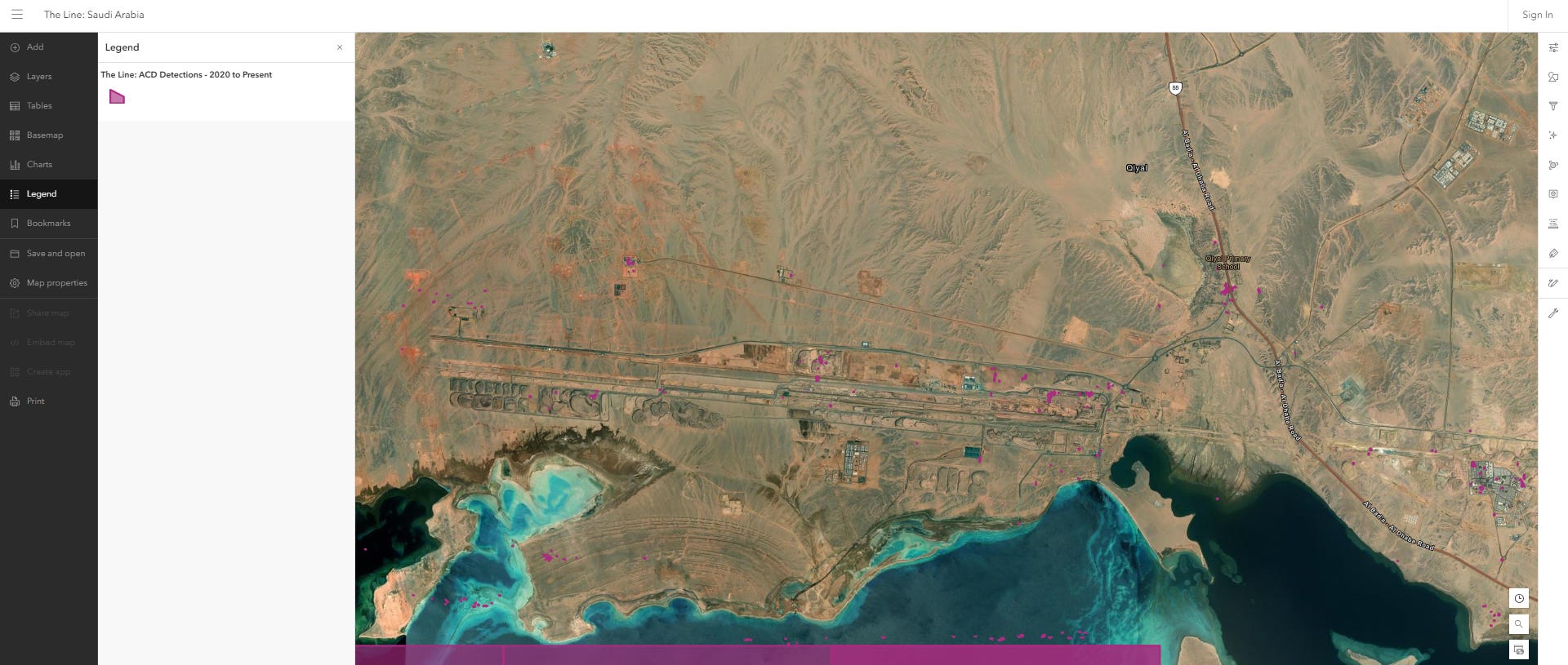
Additionally, it came up in the episode with SeerAI where Alex performed amplitude change detection analysis to detect surface disturbance on The Line in Neom, Saudi Arabia. As luck would have it, yesterday he informed me he extended the analysis coverage back to 2020 like I requested in the episode with him, check here:
The Geospatial Risk Summit is happening right now at Hard Rock Hotel, Manhattan. I confess I am distracted from a panel discussion posting this right now from the audience😬. I wanted to offer you all an impression of the kinds of discussions happening at the event. I am very grateful Iceye was willing to provide that service to us all.
Thanks Anke!
Something to note is that I was a bit flat for this episode because of the 6am start time and lack of coffee. I will improve!
Iceye is a Finland based synthetic aperture radar (SAR) constellation. They claim to have “the world's largest synthetic aperture radar (SAR) satellite constellation, ICEYE provides objective, near real-time insights, giving customers unmatched access to actionable data, day or night, even in challenging environmental conditions.”
All right that’s enough distraction for now I better start paying attention again or Priscilla will start getting annoyed…
THE GEOSPATIAL INDEX
The Geospatial Index is a comprehensive listing of all publicly traded geospatial businesses worldwide. Why? The industry is growing at ~5.4% annually (after inflation and after adjusting for base rates). This rate varies significantly, however, by sub index. For ~$400,000 to start, this growth rate is $5,000,000 over a working life. This channel, Bluesky account, newsletter, watchlist and podcast express the view that you are serious about geospatial if you take the view of an investor, venture capitalist or entrepreneur. You are expected to do your own research. This is not a replacement for that. This is not investment advice. Consider it entertainment.
NOT THE OPINION OF MY EMPLOYER
NOT YOUR FIDUCIARY
NOT INVESTMENT ADVICE
Bluesky: https://bsky.app/profile/geospatial.money
LinkedIn: https://uk.linkedin.com/in/geospatialindex
Watchlist: https://www.tradingview.com/watchlists/123254792/
Newsletter:
Spotify:

Share this post